
[This forecast has been updated: motifri.com/wx-2022-01-05-1027est]
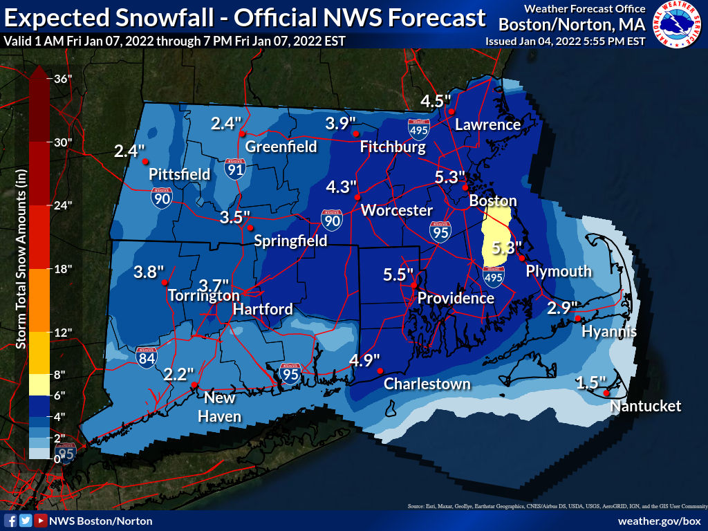
At Providence, the first significant snowfall of the season is likely Fri 3:00am-1:00pm, with snow 95% likely in the mid-morning around rush hour, possibly heavy at times, causing difficult travel. By late morning and early afternoon, from the northwest sustained winds of 15 MPH with gusts exceeding 25 MPH will cause drifting and blowing snow, further reducing visibility. While temperatures will be close to freezing, they are expected to remain several degrees below throughout the day, making any mix with or change to rain unlikely. Snow could continue as late as 5:00pm.
The median accumulation forecast in the city is 5 inches, with probabilities 85% for at least 0.1 in, 80% for 1 in, 74% for 2 in, 60% for 4 in, 44% for 6 in, 28% for 8 in, 8% for 12 in, and near 0% for 18 in. Keep in mind that accumulation forecasts are very preliminary at this point three days in advance of the storm soand may be subject to considerable change.
Before the snowstorm, the region will experience rain Wed 9:00am-Thu 2:00am with a chance of freezing rain to the north of the I-95 corridor, although temperatures in the high 40s will prevent ice accretion in the metropolitan area.
More Posts by The Author:
Heavy Rain, High Winds, Flooding Wed–Thu: Advisory for wind, watches for inland and coastal flooding posted
River Flood Warnings in RI, MA, CT: Wed through Fri, streets may be impassable at times
Snow possible but unlikely Sat mid-day: Little accumulation likely
Snow Thu Night: One inch expected
Significant Snow Storm Tue 5am – 3pm: Likely 6in but remote possibility up to 18in