
A Heat Advisory is effective until Mon 5pm in RI, MA, and CT for dangerous heat index (combination of heat and humidity), with Sun the hottest day of a multi-day heat wave. The body loses the ability to regulate its temperature by evaporating sweat, possibly causing severe illness such as heat stroke, which is life-threatening.
The heat index is an estimate of the “apparent temperature” based on the combined temperature in the shade as measured by an ordinary dry bulb thermometer and the relative humidity. Conditions in direct sunlight will usually be substantially hotter.
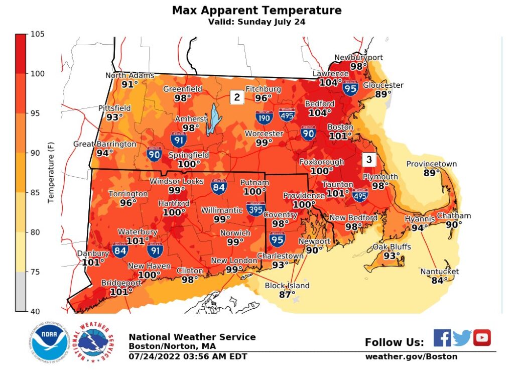
At Providence, temperatures are expected to exceed 90F from Sun 11am–5pm with a high of 95F during the middle to late afternoon, as relative humidity increases from 50% to 70% by sunset. Heat index could exceed 100 in some areas with potential for record high temperature in both Providence and Boston
.
NWS advises “Drink plenty of fluids, stay in an air-conditioned room, stay out of the sun, and check up on relatives and neighbors. Young children and pets should never be left unattended in vehicles under any circumstances. Take extra precautions if you work or spend time outside. When possible reschedule strenuous activities to early morning or evening. Know the signs and symptoms of heat exhaustion and heat stroke. Wear lightweight and loose fitting clothing when possible. To reduce risk during outdoor work, the Occupational Safety and Health Administration recommends scheduling frequent rest breaks in shaded or air conditioned environments. Anyone overcome by heat should be moved to a cool and shaded location. Heat stroke is an emergency! Call 911.”
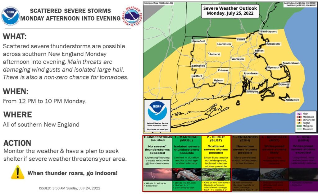
Rain is likely Mon 1–10pm with a potential for isolated thunderstorms, possibly severe, throughout this period as well as several hours before and after. The main risk from these thunderstorms will be heavy rain, strong straight-line wind gusts, and isolated large hail; there is a small but significant chance of rotational wind that could turn into a life-threatening tornado upon touching ground.
Despite the rain Mon, temperatures just below 90F (thereby ending the official multi-day heat wave) combined with uncomfortable relative humidity 70-90% will result in heat index of 98, so the same precautions should be observed as for a heat wave, especially with regard to outdoor activity.
Tue and Wed are expected to be seasonably pleasant, with daytime high temperatures in the mid-80s and evening low temperatures in the mid-60s, and the next chance of precipitation Wed evening.
More Posts by The Author:
Heavy Rain, High Winds, Flooding Wed–Thu: Advisory for wind, watches for inland and coastal flooding posted
River Flood Warnings in RI, MA, CT: Wed through Fri, streets may be impassable at times
Snow possible but unlikely Sat mid-day: Little accumulation likely
Snow Thu Night: One inch expected
Significant Snow Storm Tue 5am – 3pm: Likely 6in but remote possibility up to 18in