Driving has recently taken a turn for the worse in RI. Last December, officials closed the westbound span of the Washington Bridge, narrowly averting an actual calamity, they say. In doing so, they also summoned the specter of Carmageddon across the East Bay and Southeastern Massachusetts. Traffic on I-195 now slows to a crawl in both directions as drivers merge into the long queue before the half-capacity bridge. Trip times have multiplied unpredictably.

We all know the toll traffic takes on the mind. You’re confined in the car, trapped by the other drivers. Your back hurts, your legs are asleep, you need to go to the bathroom. A line of cars in front of you expands and contracts, creeping forward like a huge caterpillar, and eventually, somehow, you emerge onto the open road, but the frustration lingers. Everything on the road feels like an obstacle, and you just want to get out of the car.
I hate the stress and unpredictability of being trapped in traffic and go out of my way to avoid driving because of it.
What can we do to alleviate drivers’ woes? In one distressingly firm response to bridge bottlenecking and increased cut-through traffic, PVD Mayor Brett Smiley has proposed to “relocate” the South Water Street Trail onto the sidewalk, in order to recreate its former two-lane configuration, giving the bike lane space back to traffic. It’s not because traffic is backed up there now, officials say. They want to reroute cut-through traffic from Eddy St. onto South Water to accommodate the cars and trucks ducking through the city to avoid merging from 95 North onto 195 East. Essentially, they plan to let frustrated drivers run bikers over, and sacrifice a jewel of the Riverwalk in order to make an extended on-ramp. Don’t they know that May is Bike Month? Now is the perfect time to explore PVD’s bike network, to activate it, and encourage people to try it as a way to get around. Yet, the response is to commit to cars at the expense of everything else.
What relief, if any, would be gained by letting cars run down that bike lane? Changing where you’re stuck in traffic doesn’t make it any less torturous. Aren’t people from the community and all over enjoying the pedestrian bridge and all of the paths on the waterfront? It’s easy to walk around, which is good for business. One South Water St. restaurateur testified to the City Council that in the two years since the bike lanes were added, his Waterfire weekend sales leapt, because visitors could now cross the street much more easily. The single lane configuration of South Water isn’t a bug, it’s a feature — an essential part of what makes the area safe.
I use the bike lanes five days a week coming home from work, to get from Providence Station to the East Bay Bike Path. Even during rush hour, cars, bikes, and pedestrians all move freely and safely through and around the area. Stop-and-go traffic is rare on South Water, and cars don’t race down the street, because they can’t — there’s only one lane.
The real problem is that the bike lanes spill out into traffic at Dollar St.and abruptly end at Wickenden St.
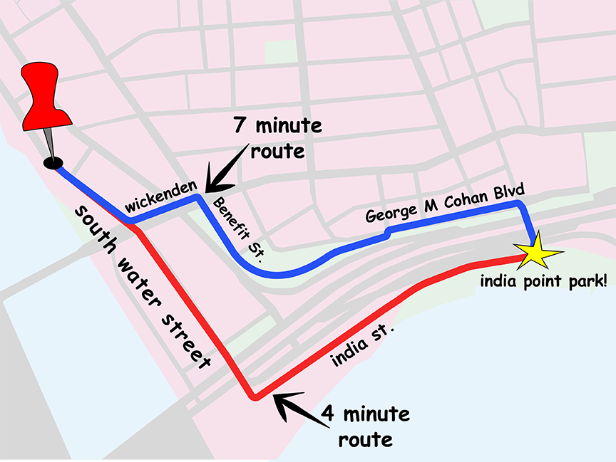
South Water St.and India St. make a flatter, more direct route into India Point than following the current bike path up the hill and taking the Park bridge over the highway.
Cyclists are allowed to bike this route now, but it doesn’t feel safe to most people. It leads to an on-ramp. The span of 195 looms ominously. Cars speed up to overtake you, just as the shoulder shrinks to a tiny sliver and finally disappears. The street signs read “BIKE LANE ENDS” actively discouraging most cyclists from even thinking about it.
But you can imagine something different there: the South Water St. Trail expanded, creating a new greenway connection between Providence and the East Bay, gaining us some relief from traffic on a shorter timeline than the three years predicted to rebuild the bridge. This moment calls for more transportation options, not fewer. Instead, we find ourselves rallying to protect a crucial active transportation link that is under attack.
I commute by bike from East Providence and take a train to Boston every day. The route I take is about two-thirds bike path, and I enjoy my 15 to 20 minute ride every morning and evening. If you’ve been curious about commuting by bike, consider this your invitation. The South Water St. lanes help make it a stress-free trip.
RI has over 60 miles of world-class bike trails. It’s time we connected them to our neighborhoods and promoted them in our communities. I live a half mile from the start of the East Bay Bike Path, but when I’m with my family, we usually take the car together. It feels unsafe to bike with my 12-year-old even a mile or two, because the safe connections are missing. The South Water St. Trail is a shining counter example. That bike lane makes the area feel much safer and more comfortable to visit and walk around. Let’s build upon this, rather than tear it, and other urban trail connections down. When we develop bike connectivity as part of our transportation network, even those who don’t bike will benefit.
Here’s my call to action: Think of a place you can go by bike and cut out the car entirely — grab a coffee, browse at a bookstore, pick up a gallon of milk. Then grab your bike and take the ride, and ask yourself: Do I want fewer bike lanes, or more? Then, make sure you speak up.
Follow Sam on Instagram @wildbikeslife.
The opinions expressed in this article are those of the author and do not necessarily represent those of Motif.