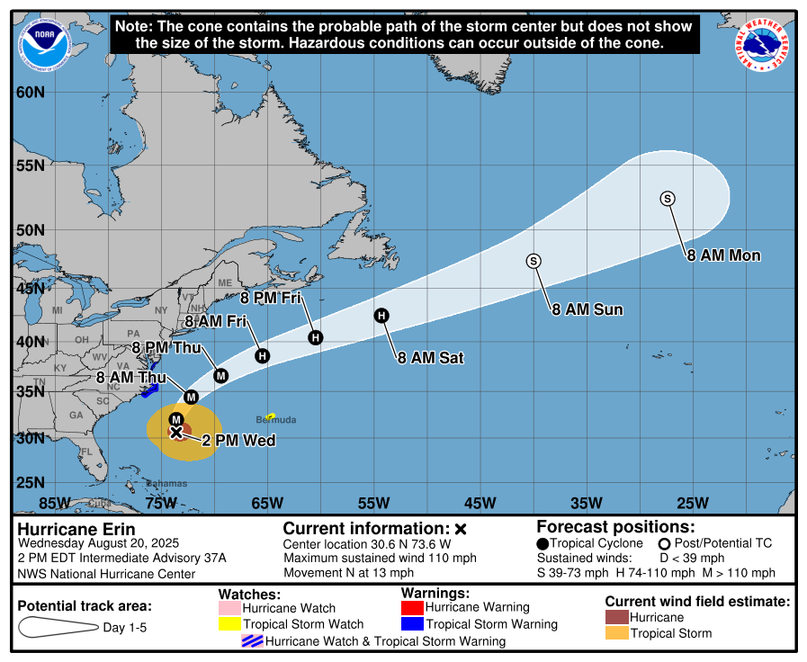
Hurricane Erin is currently at Category 2 on the Saffir-Simpson wind speed scale with maximum sustained winds of 110 MPH, and further increase in strength is likely. H. Erin briefly on Sat reached Category 5 with maximum sustained winds of 160 MPH, a significant rarity. Remember that this scale accounts only for wind speed and does not reflect other potentially deadly risks such as rainfall amounts and storm surge. H. Erin is large, with hurricane force winds extending from the center up to 105 miles and tropical storm force winds up to 265 miles.
While H. Erin poses no immediate threat to New England, it would be prudent to remain alert and keep updated as it progresses northward over the Atlantic. The predicted track keeps the storm well offshore, but any changes that bring it closer would have effects no earlier than Thu and more likely Fri. At Providence, chance of rain will exceed 80% through Thu 4am. Forecast models predict a cumulative 4% chance of tropical storm force winds at Providence from Thu through Fri.

A Storm Surge Warning is in effect for Cape Lookout to Duck, North Carolina. A Tropical Storm Warning is in effect for Beaufort Inlet, North Carolina to Chincoteague, Virginia, including Pamlico and Albemarle sounds. A Tropical Storm Watch is in effect for Bermuda.
A Tropical Storm Warning means that tropical storm conditions are expected somewhere within the warning area within the next 24 hours. A Tropical Storm Watch means that tropical storm conditions are possible within the watch area, generally within 48 hours.
A Storm Surge Warning means there is a danger of life-threatening inundation, from rising water moving inland from the coastline, during the next 36 hours in the indicated locations. This is a life-threatening situation. Persons located within these areas should take all necessary actions to protect life and property from rising water and the potential for other dangerous conditions. Promptly follow evacuation and other instructions from local officials.
In addition to high winds, life-threatening surf and rip currents are likely, as well as 2 – 4 inches of rain over affected land areas and 12 – 16 inches over water.