Nationally relevant
Articles relevant beyond the local area
Articles relevant beyond the local area
At Providence, a minor but complicated storm will begin Fri 12pm as rain, change by 2pm to snow, then by 4pm to freezing rain and sleet, then by 9pm to snow, ending Sat 3am. Snow accumulation 1 – 3 inches expected. Ice accretion on tree limbs and electrical lines could cause power outages. Metropolitan area […]
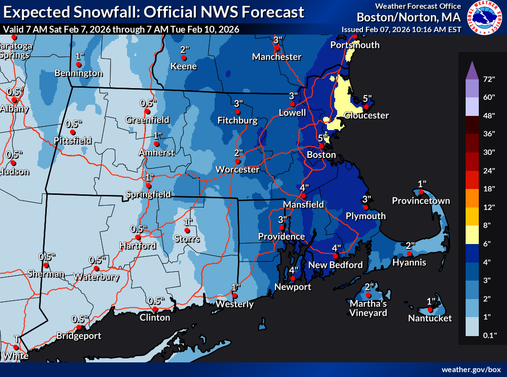
Cold Weather Advisory in effect from February 7, 06:00 PM EST until February 8, 01:00 PM EST Winter Weather Advisory in effect from February 7, 04:00 AM EST until February 7, 07:00 PM EST At Providence, a strong storm well offshore Sat 1am – 6pm will bring 2 – 4 inches snow. A Winter Weather […]
At Providence, a storm passing offshore could bring minimal snow, most likely Sun morning before mid-day. Metropolitan area probability is of at least 0.1in 55%, 1in near 0%. This implies a 45% probability of no snow at all. Unseasonable cold continues overnight Sat – Sun, with ambient temperature as low as 8°F and wind chill […]
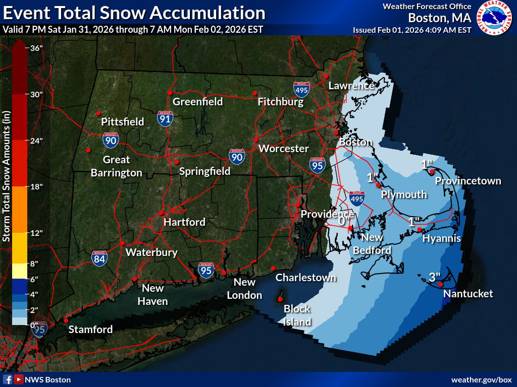
Winter Storm Warning until January 26, 08:00 PM EST At Providence, a major storm dropped as much as 16 – 18 inches of snow according to reports from the metropolitan area, decreasing to 14 – 16 inches in outer areas of the state. A Winter Storm Warning remains in effect until Mon 8pm, with an […]
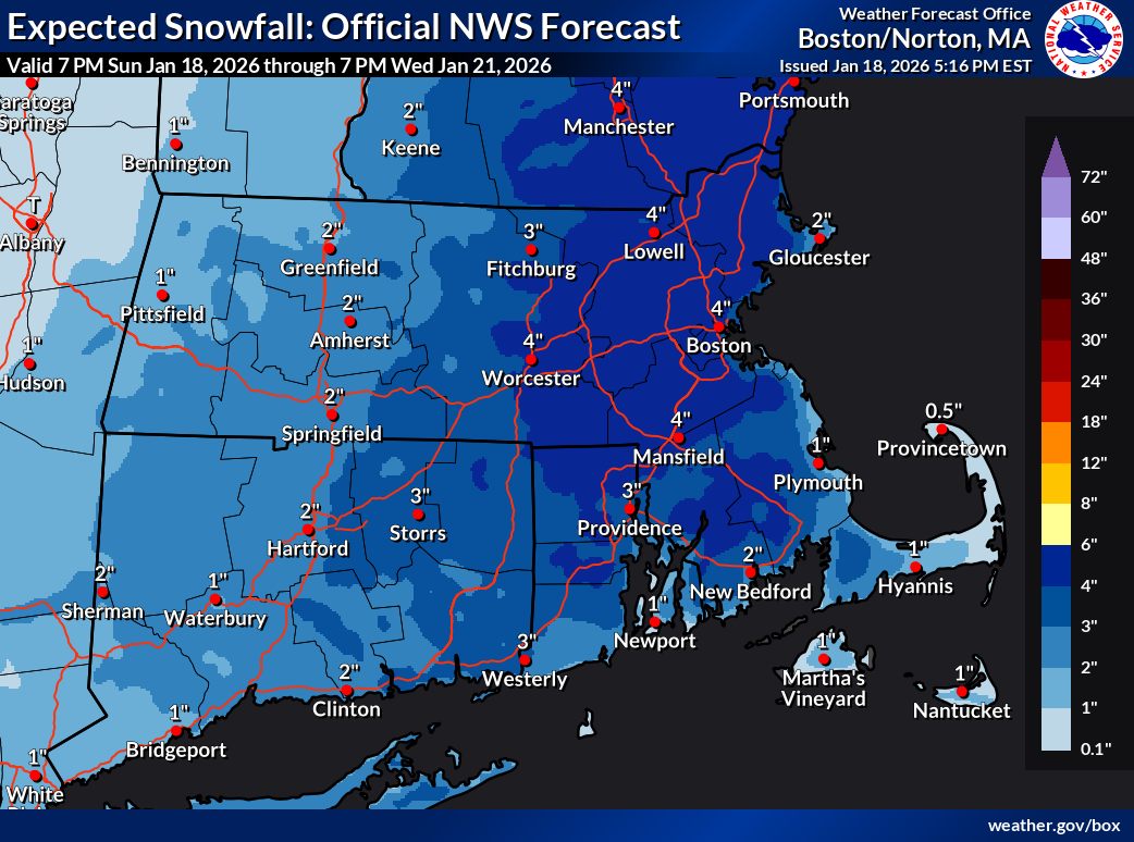
Winter Weather Advisory in effect from January 18, 07:00 AM EST until January 19, 07:00 AM EST At Providence, a developing offshore coastal storm is expected to bring 2 – 4 inches of snow Sun 7am – Mon 3am, peaking Sun 5pm – Mon 1am with possible snowfall rates of 0.5 inch per hour. A […]
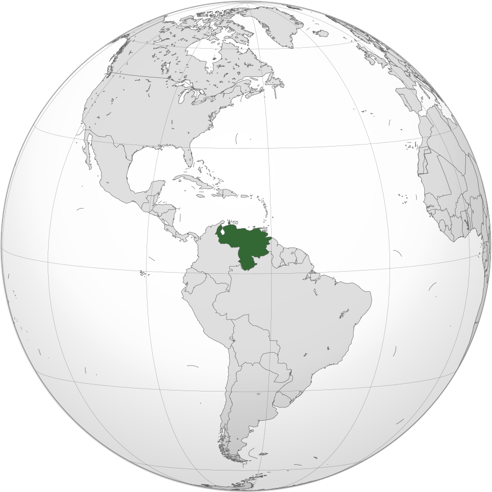

News broke of an audacious operation on Jan 3 where US forces flew into Caracas, the capital of Venezuela, captured dictator Nicolás Maduro and his wife, and flew them out to stand trial in federal court in New York City. For days, Americans were glued to the news media wondering, “Where the hell is Venezuela?” […]

At Providence, a clipper low Mon night followed by a shortwave Tue night into Wed morning will bring two separate episodes of precipitation, the first beginning as minimal snow possibly changing to freezing rain and the second almost all rain. Snow is likely to begin Mon 7pm and possibly change to freezing rain 9pm before […]
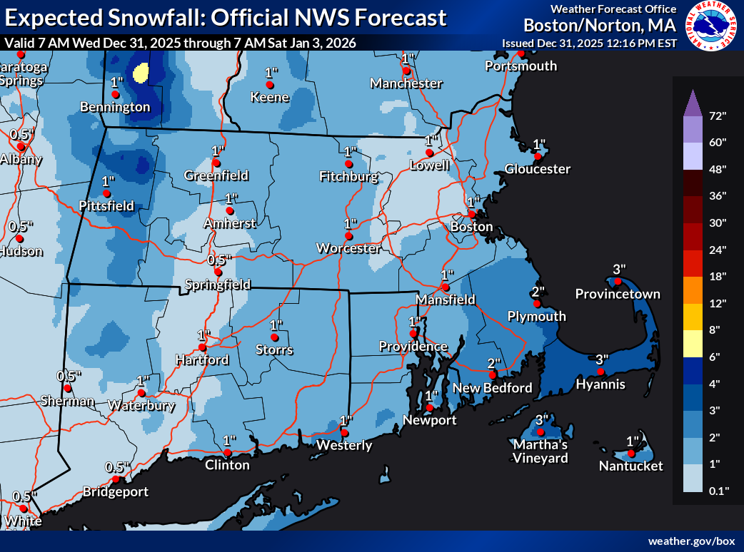
Winter Weather Advisory in effect from December 31, 07:00 PM EST until January 1, 01:00 PM EST At Providence, a shortwave interacting with an arctic cold front is expected to bring 1 – 3 inches of snow Thu 12am – 7am. A Winter Weather Advisory is posted for Wed 7pm – Thu 1am. Current probability […]
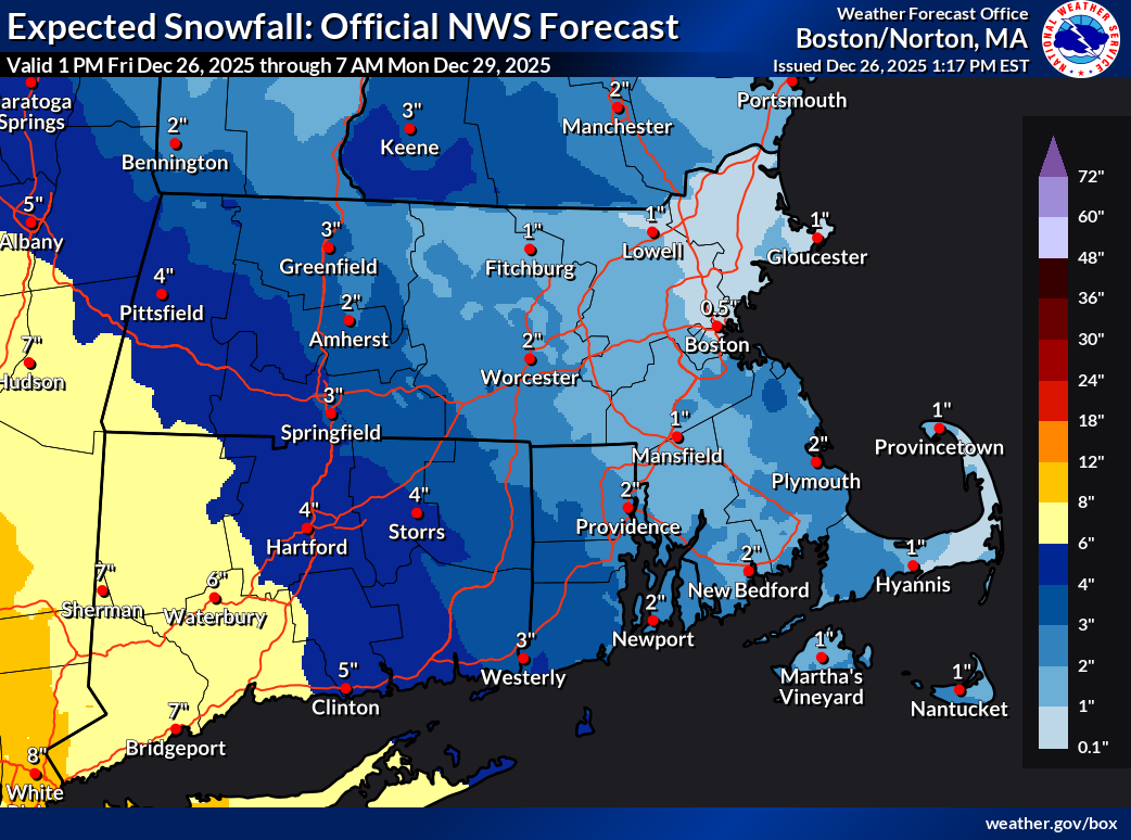
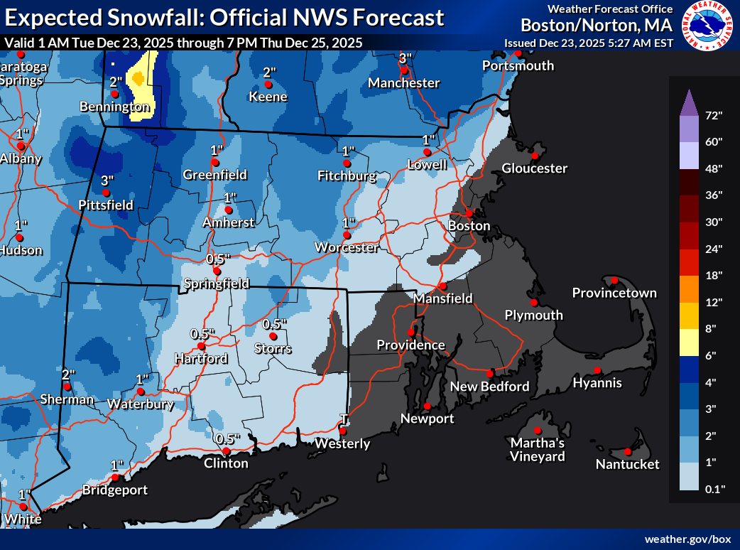
Winter Weather Advisory in effect from December 26, 07:00 PM EST until December 27, 10:00 AM EST At Providence, a clipper system is expected to bring 2 – 4 inches of snow Fri 9pm – Sat 8am. A Winter Weather Advisory Fri 7pm – Sat 10am covers RI south of Providence, including Bristol, Kent, and […]
At Providence, a shortwave trough interacting with a warm front from the southwest is expected to bring up to 1 inch of snow beginning Tue 9am, mixing with rain 11am, changing to all rain by 5pm, then possibly changing back to snow briefly before ending 10pm. Temperatures well above freezing, reaching 36°F in the afternoon, […]