Weather
Weather updates, focusing on warnings, watches, and unusual conditions.
Weather updates, focusing on warnings, watches, and unusual conditions.
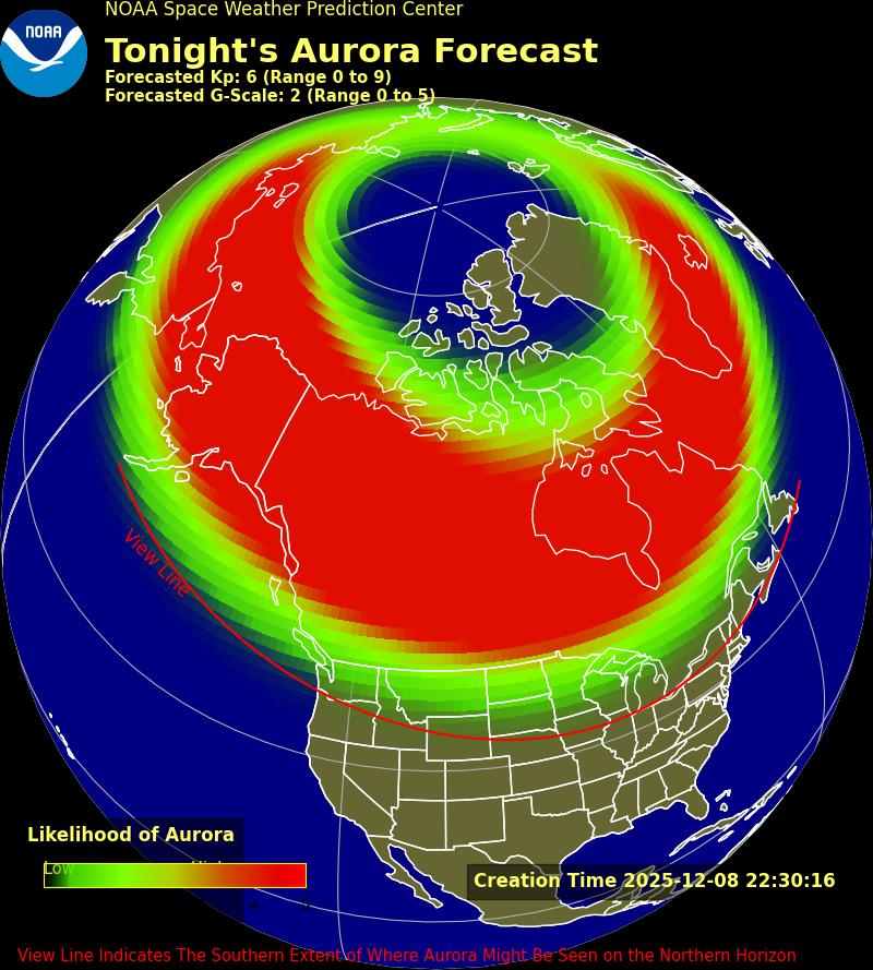

At Providence, solar aurora may be visible overnight Mon into Tue and, to a lesser extent, Tue into Wed. Aurora is unusual at latitudes this far south, but it typically happens a few times every year. Weather at Providence during the potential aurora will be partly cloudy increasing from 25% cloud cover Mon sunset to […]


At Providence, a significant nor’easter Tue is expected to bring almost entirely rain, heavy at times, with perhaps a sighting of the first snowflakes of this winter season but negligible accumulation. Early uncertainty in the forecast has resolved strongly toward an all-rain event, but minor changes to the predicted storm track, slightly northward or southward, […]


Scientific models forecasting the upcoming winter season are driven mostly by observations of such factors as Pacific Ocean temperature, since weather moves from west to east across the continental United States. It has been known for more than a century that worldwide seasonal phenomena were correlated with trade winds and ocean water temperature, controlling the […]


At Providence, solar aurora may be visible overnight Tue into Wed and, to a lesser extent, Wed into Thu. Aurora is unusual at latitudes this far south, but it typically happens a few times every year. Weather at Providence during the potential aurora will be partly cloudy increasing from 40% cloud cover Tue sunset to […]


Wind Advisory in effect from October 31, 02:00 PM EDT until November 1, 05:00 AM EDT At Providence, remnants of Hurricane Melissa although far offshore will combine with a conventional storm system approaching from the west to bring heavy rain Thu 4pm – Fri 5am, possibly as much as 2 inches of rainfall, with chance […]


At Providence, solar aurora may be visible overnight Mon into Tue, although fairly unlikely. Aurora is unusual at latitudes this far south, but it typically happens a few times every year. Weather at Providence during the potential aurora will be partly cloudy with about 50% cloud cover, temperature about 60°F and near-zero chance of rain. […]


Hurricane Erin is currently at Category 2 on the Saffir-Simpson wind speed scale with maximum sustained winds of 110 MPH, and further increase in strength is likely. H. Erin briefly on Sat reached Category 5 with maximum sustained winds of 160 MPH, a significant rarity. Remember that this scale accounts only for wind speed and […]


Heat Advisory in effect from July 28, 11:00 AM EDT until July 30, 08:00 PM EDT At Providence, a Heat Advisory is in effect through Wed 8pm with temperatures/heat indices reaching 94°F/99°F (Wed). Temperature/heat index will decline after the advisory period, remaining comfortably warm, 76°F/76°F (Thu), 67°F/67°F (Fri). Chance of rain Thu morning through Fri […]


Heat Advisory until July 25, 08:00 PM EDT At Providence, a Heat Advisory is in effect through Fri 8pm with temperatures/heat indices reaching 93°F/102°F (Fri). Temperature/heat index will decline after the advisory period, remaining comfortably hot, 83°F/83°F (Sat) and 80°F/82°F (Sun). Chance of rain Fri, with possibly severe thunderstorms, will exceed 20% between 1pm and […]


Heat Advisory in effect from July 15, 11:00 AM EDT until July 17, 07:00 PM EDT At Providence, a Heat Advisory is in effect Tue 11am through Thu 7pm, likely to be extended into Fri, with temperatures/heat indices reaching 85°F/94°F (Tue), 88°F/98°F (Wed), 86°F/97°F (Thu), and 87°F/94°F (Fri). Temperature/heat index will decline somewhat after the […]